Table of Contents
ToggleAkola City

Akola City, located in the Vidarbha region of Maharashtra, is a vibrant and historically significant destination known for its cultural heritage, agricultural prominence, and rapid urban development. Often referred to as the “Cotton City of India,” Akola plays a crucial role in Maharashtra’s agrarian economy. With a rich history dating back to ancient times, the city is a blend of tradition and modernity, offering a unique experience to residents and visitors alike.
Historical Significance
Akola city has a deep-rooted history that can be traced back to various dynasties, including the Mauryas, Satavahanas, Rashtrakutas, and Mughals. The city has witnessed the influence of Maratha rulers, especially under the Peshwas, who played a significant role in shaping its legacy. During British rule, Akola was an important administrative center, contributing to its development and infrastructure growth. Today, remnants of its historical past can still be seen in its forts, temples, and old markets.
Geography and Climate
Akola City is strategically located in western Vidarbha, surrounded by districts like Amravati, Washim, and Buldhana. The city enjoys a tropical climate, characterized by hot summers, moderate monsoons, and pleasant winters. The Purna River, a tributary of the Tapti River, flows near Akola, contributing to its agricultural richness. The region is also known for its black soil, which is highly fertile and ideal for cotton farming.
Agricultural and Economic Importance
Akola is one of the leading cotton-producing regions in India, earning it the title of “Cotton City.” The presence of numerous ginning and pressing mills has made the city a major hub for the cotton trade. Apart from cotton, soybean, jowar, and pulses are widely cultivated, supporting the economy and employment in the region. The Agricultural University in Akola, Dr. Panjabrao Deshmukh Krishi Vidyapeeth, plays a pivotal role in research and development in the field of agriculture.
Cultural and Religious Significance
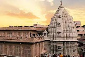
Akola City boasts a rich cultural heritage, with diverse communities coexisting harmoniously. Festivals like Diwali, Ganesh Chaturthi, Eid, and Makar Sankranti are celebrated with great enthusiasm. The city is home to several religious sites that attract devotees from across the region. Some of the prominent temples include the Raj Rajeshwar Temple, Narsingh Maharaj Temple, and Birla Ram Mandir. There are also important mosques and churches, reflecting the city’s cultural diversity.
Tourist Attractions in Akola
Despite being known for its agricultural and trade significance, Akola also has several attractions for tourists and history enthusiasts.
- Narnala Fort – Located near Akola, this ancient fort dates back to the Gond dynasty and later came under the rule of the Mughals and Marathas. It is a must-visit for history lovers.

- Akola Fort – A historic fort that showcases the architectural brilliance of the Mughal era.

- Raj Rajeshwar Temple – A famous Shiva temple that draws devotees, especially during Mahashivratri.

- Shegaon – Located close to Akola, Shegaon is home to the famous Gajanan Maharaj Temple, a major pilgrimage site in Maharashtra.
Education and Development
Akola City is an educational hub in Vidarbha, with several schools, colleges, and universities contributing to academic excellence. Dr. Panjabrao Deshmukh Krishi Vidyapeeth is a premier agricultural university, offering advanced research opportunities in farming and biotechnology. Engineering, medical, and management institutes in the city provide quality education, attracting students from nearby districts.
Infrastructure development in Akola has been on the rise, with improvements in transportation, healthcare, and industries. The city has a well-connected road and railway network, making travel easy. The Akola Junction railway station is a key stop on the Mumbai-Nagpur route, facilitating smooth connectivity. The ongoing development projects aim to modernize the city while preserving its historical essence.
Transport and Connectivity
Akola is well-connected by road, rail, and air, making it an accessible city for travelers and businesses.
- By Road: Akola has a robust road network, with national and state highways linking it to major cities like Nagpur, Amravati, Aurangabad, and Pune. The Maharashtra State Road Transport Corporation (MSRTC) operates buses connecting Akola to other parts of the state.
- By Rail: Akola Junction is an important railway station on the Mumbai-Bhusawal-Nagpur line. Several express and passenger trains pass through the city, ensuring excellent rail connectivity.
- By Air: The nearest airport is Akola Airport, primarily used for regional and domestic flights. The nearest major airport is Dr. Babasaheb Ambedkar International Airport in Nagpur, about 250 km away.
Industries and Trade
Apart from agriculture, Akola has a thriving industrial sector, with businesses ranging from textile mills and oil production units to small-scale industries. The city’s cotton mills are among the largest in Maharashtra, contributing significantly to the state’s textile industry. The presence of agro-based industries and emerging businesses in manufacturing, retail, and IT has further strengthened Akola’s economy.
Healthcare Facilities
Akola is equipped with well-established healthcare facilities, catering to the medical needs of its residents. The city has several multi-specialty hospitals, government medical centers, and private clinics providing quality healthcare services. The presence of medical colleges also ensures the availability of trained professionals and advanced medical treatments.
Festivals and Celebrations
Festivals play an integral role in the cultural vibrancy of Akola. From grand Ganesh Chaturthi processions to the colorful celebrations of Diwali and Holi, the city comes alive with joy and enthusiasm. The annual Urs at prominent dargahs and Christmas celebrations at churches reflect the city’s inclusive nature. Traditional fairs and local markets during festive seasons attract visitors from surrounding areas.
Modern Lifestyle and Entertainment
Akola offers a blend of traditional and modern lifestyles. The city has bustling markets, shopping malls, multiplexes, and restaurants that cater to diverse tastes. The local cuisine, influenced by Maharashtrian flavors, includes popular dishes like puran poli, misal pav, and varhadi food. Parks and recreational spots provide leisure options for families and tourists.
Future Prospects and Urban Growth
With rapid urbanization, Akola is witnessing infrastructural growth in various sectors, including real estate, education, and healthcare. Smart city initiatives, improved road networks, and technological advancements are shaping Akola into a progressive city while retaining its cultural heritage. Government initiatives in agriculture and trade are also contributing to economic prosperity.
Conclusion
Akola City is a perfect example of tradition meeting progress. From its historical landmarks and religious significance to its role in agriculture and urban development, Akola continues to grow as a key city in Maharashtra. With its rich cultural heritage, strong economic foundation, and promising future, Akola remains a significant hub in the Vidarbha region. Whether one visits for its historical sites, spiritual centers, or bustling markets, Akola City offers a unique experience filled with warmth, tradition, and modern aspirations
